Jeddah
lundi 20 février 2017 à 17:54Thomas Pesquet posted a photo:
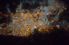
The city of Jeddah, under some clouds coming from the red sea
La ville de Djeddah, sous quelques nuages venus de la mer Rouge
Credits: ESA/NASA
133C9845
Site original : Uploads from Thomas Pesquet
Thomas Pesquet posted a photo:
The city of Jeddah, under some clouds coming from the red sea
La ville de Djeddah, sous quelques nuages venus de la mer Rouge
Credits: ESA/NASA
133C9845
Thomas Pesquet posted a photo:
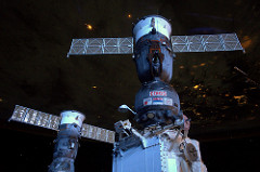
This pic doesn’t look like much, but there’s a lot in here. The Earth is still in darkness, but the International Space Station is lit by sunlight that starts to reach us as the Sun peeks over the horizon. It’s the same for mountains: the higher the altitude, the earlier you see the Sun in the morning, and the later at night… it’s geometry! You can see the International Space Station from Earth at dawn and dusk, when sunlight reflects on our solar panels and the station structure: we don’t have lights bright enough to illuminate us other than the Sun’s reflection! We fly roughly from West to East and appear as a bright star that moves at constant speed over the horizon, like a satellite (but brighter) or like an aircraft (but faster and without flashing lights). Many apps or websites show you where the Space Station is right now over Earth and calculate when you will be able to see it. If you are North of where we fly look South and vice-versa, the further away you are from our position over ground the more lower we will appear over the horizon. But don’t worry, the apps will send you alerts of when to look up, and even tell you where in the sky to look for the International Space Station. If you take a picture and set a long exposure you can get some cool star-trails. Here are some pictures people have sent me since my mission began, it is a great hobby to understand photography and spacecraft orbits!
Cette photo n’a l’air rien de rien, mais elle dévoile un aspect intéressant du vol orbital. Le côté de la planète que nous survolons est toujours plongé dans l’obscurité, mais les rayons du soleil, qui émerge à l’horizon, éclairent déjà l’ISS (ici, notre Soyouz) ! C’est le même principe qu’avec les montagnes sur Terre : plus les sommets sont élevés, et plus tôt se remarquent le lever du soleil le matin et son coucher le soir… C’est tout simplement géométrique.
C’est pour cette raison que la Station spatiale peut être vue depuis la terre à l’aube ou au crépuscule, c’est-à-dire quand les rayons du soleil se reflètent sur nos panneaux solaires mais que la nuit est déjà tombée sur Terre. L’ISS vole d’ouest en est et ressemble à une étoile particulièrement brillante qui se déplacerait rapidement et à vitesse constante à l’horizon. Il existe de nombreuses applications et sites internet pour connaître la position exacte de l’ISS et le moment exact où elle passera au-dessus de vos têtes. Ci-dessous quelques photos qu’on m’a envoyé depuis le début de ma mission – c’est un passe-temps sympa pour mieux comprendre l’orbite des vaisseaux spatiaux et les méthodes d’exposition longue en photographie !
Credits: ESA/NASA
144A2445
Thomas Pesquet posted a photo:
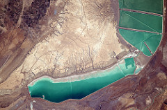
Béziers with the Orb river and the amazing engineering project Canal du Midi
Béziers, l’Orb et surtout la merveille de génie civil : le Canal du Midi !
Credits: ESA/NASA
145A1481
Thomas Pesquet posted a photo:
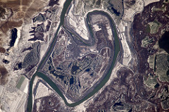
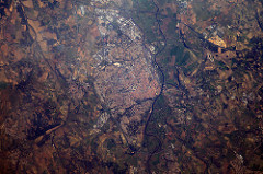
Oddly bent river somewhere in Moldavia
Ce fleuve fait un étrange coude, quelque part en Moldavie – un paléoméandre en devenir peut-être?
Credits: ESA/NASA
145A0793