Pyongyang photo mapping
mercredi 15 septembre 2021 à 21:03Thomas Pesquet posted a photo:
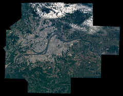
Nous avons survolé la zone démilitarisée et lourdement gardée qui chevauche la frontière entre la République populaire démocratique de Corée et la République de Corée. Le contraste est très visible de jour mais il est encore plus marquant de nuit : les lumières du sud et de Seoul se transforment en obscurité totale dès la frontière passée, à la rare exception de Pyongyang, seule tache de lumière dans un pays obscur. Peu de gens ont l’opportunité de zoomer sur Pyongyang, ce qui fait de ce photocollage une bonne occasion de l’explorer : vous ou moi n’approcherons sans doute jamais la ville de plus près.
We flew over the de-militarised zone, the heavily guarded border between the Democratic People’s Republic of Korea and Republic of Korea. You see the contrast by day, but it’s even more striking at night: the brightly lit area on the left is Seoul and the south of the Korean peninsula, and it turns into almost complete darkness right after the border... the only small spot of lights is Pyongyang. I could zoom up on the capital city of DPRK, not many people are in a position to do so… explore the city in the Big Picture mapping, that’s probably as close to it as you’ll ever get to the city, and me too: www.esa.int/ESA_Multimedia/Images/2021/09/Pyongyang_photo...
Expedition 65 earth observation composite of Pyongyang, North Korea photographed by ESA astronaut Thomas Pesquet (created with iss065e242955 - iss065e242995).
GMT227_00_08_For ESA_Thomas Pesquet_Pyongyang Seoul - 1120mm mapping
jsc2021e037840-Pyongyang